
Sweetwater Creek Yellow Trail & Orange Trail
Want the perfect Atlanta hike for mill ruins and skyline views? The Sweetwater Creek Yellow Trail and Orange Trail is the just the hike for you!
This 5.5 mile hike at Sweetwater Creek State Park has great views of the mill ruins and the Atlanta skyline. And I love hiking these trails during the spring!
Enjoy some time outdoors with this breathtaking hike in one of Atlanta’s most beautiful state parks. Here’s what you need to know about hiking the Sweetwater Creek Yellow Trail and Orange Trail.
Sweetwater Creek Yellow Trail Hike
The hike on the Sweetwater Creek Yellow Trail starts at the Sweetwater Creek Interpretive Center.
You actually start on the Red Trail, but the access to the Sweetwater Creek Yellow Trail isn’t too far ahead. In the spring, you can see the yellow marker through the trees from the beginning of the trail.
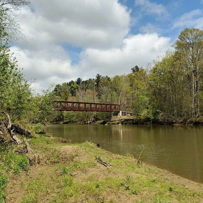
The Yellow Trail follows the park’s namesake Sweetwater Creek upstream, reaching a steel bridge at 0.65 miles.
Across the bridge, the trail meets the Orange Trail, but instead of getting on that trail now, we continued following the Yellow Trail downstream. Where the trail forks, we continued straight, taking the loop counterclockwise, to the toughest part of the hike.
At about 1.2 miles, there is a small offshoot trail to the right that follows along the creek, through blooming pink and white mountain laurels, to a cross-creek view of the New Manchester Mill. On our cloudy hike, the mill ruins sat like a castle on a stormy shore.

The trail retraces back to the Sweetwater Creek Yellow Trail and continues up, up, up through 350 feet of elevation. (Taking the trail clockwise is supposed to make this ascent much more gradual than our counterclockwise approach.)
As the trail continues to climb, there is a large rock overhang that the Native Americans used as shelter for thousands of years.
Once at the top of the hill, the Sweetwater Creek Yellow Trail meets the “lollipop” loop of the Orange Trail at about 1.5 miles.
Sweetwater Creek Orange Trail Hike

The Orange Trail branches off to the right of the Yellow Trail, following south and counterclockwise for about 1.3 miles. The trail ambles through a lesser-used area of the forest. We even saw three deer leaping across the path further ahead of us.
At just over 3 miles, the forest opens up, with much fewer trees overhead. The red dirt and young forest surrounding start to look more like South Georgia than North Georgia.
At the intersection of the Orange Trail’s lollipop stem and the rest of the loop, you can branch off to the right through the baby pine trees to catch a glimpse of the skyline through the trees. Spring, fall, and winter will be the best time to see this skyline view, as the foliage would be too full during the summer for a clear view.
Back on the trail, we continued left to finish off the last little bit of the Orange Trail loop and hop back on the Yellow Trail.
Back on the Sweetwater Creek Yellow Trail
The Yellow Trail continues north and this time gradually descends the 350 feet. The hike down is obviously much more pleasant than the hike up.
The trail ends its loop at about 3.9 miles where we turned right and continue back the way we came over the bridge and this time downstream along the river.
Continuing back to the Interpretive Center would make this about a 4.5 mile hike, but instead of doing this, we decided to stop off to see the mill ruins up close and personal.
Bonus: Sweetwater Creek Red Trail

To get to the Red Trail from the Yellow Trail, we just continued to follow the creek downstream at a fork.
On the Sweetwater Creek State Park trail map, this fork is marked by a black trail connector.
Once connected with the Red Trail, the hike continues for about 0.5 miles past the ruins of the mill town and the man-made channel to the New Manchester Mill. This 5-story mill was burned down by Union troops during the Civil War in 1864 and has stood as picturesque ruins ever since.
We sat by the ruins, ate lunch, and rested a bit before hiking the 0.5 miles back to the Interpretive Center, ending our Sweetwater Creek hike at about 5.5 miles.

Planning your first trip to Atlanta?
Get your FREE Welcome To Atlanta Kit, complete with a budget guide, hidden gems, travel planners, and more!
Hiking Essentials
Come prepared for your hike by making sure you pack the essentials. Check out this must-have hiking gear before you set off on the trails:
Want to learn all about Atlanta? Check out my new book, What’s With Atlanta?: The Quirks, Personality, and Charm of the ATL. Whether you’re a local or are just passing through, this entertaining guide will answer all of your Atlanta questions.
Sweetwater Creek Yellow Trail & Orange Trail Info
Hike length: Yellow Trail: 3 miles; Orange Trail: 2.3 miles
Difficulty: Moderate to Difficult
Is it pet-friendly?: Yes, leashed dogs are allowed on this trail.
Location: 1750 Mt Vernon Rd, Lithia Springs, GA 30122
Parking: Parking is available at Sweetwater Creek State Park Interpretive Center. $5 fee.
Fees: $5 parking fee per vehicle.
Hours: The trail is open from 7 a.m. to dark.
Accessibility: The Sweetwater Creek Yellow Trail and Orange Trail are unpaved dirt trails with multiple inclines. The trails can be muddy at times.
About Sweetwater Creek State Park
Sweetwater Creek State Park in Lithia Springs, Georgia is home to 15 miles of hiking trails, camp sites, and a set for The Hunger Games movies.
The ruins of the New Manchester Mill were used in The Hunger Games: Mockingjay Part 1 as part of the ruins for District 13. The short and easy hike to this film set coupled with the park’s close proximity to Atlanta makes the state park a popular hiking destination.
We’ve previously hiked Sweetwater Creek State Park’s White and Red Trails, which is the most popular hiking route.

Ultimate Atlanta 5 Day Itinerary
Your Atlanta vacation — planned for you.
Don’t spend any more time stressing about planning your Atlanta getaway. Get this done-for-you, fully planned itinerary!
Save on Atlanta’s Top Attractions
Want to save big on Atlanta’s top attractions? with the Atlanta CityPASS, you can save up to 50% on the cost of entrance tickets to 5 top Atlanta museums and attractions!
Get admission to your choice of 5 from the Georgia Aquarium, the World of Coca-Cola, and Zoo Atlanta, the Fernbank Museum of Natural History, the College Football Hall of Fame, and the National Center for Civil and Human Rights.
Top Atlanta Tours
A guided tour is always a good way to get to know a city! Check out these top Atlanta tours.
- 90-Minute Guided Sightseeing Tour by E-Car
- Atlanta’s Black History and Civil Rights Tour
- Midtown Atlanta Food & Cocktail Tour
Where to Stay in Atlanta
Find the perfect place to rest your head on your Atlanta vacation!
- My Favorite Stay: Westin Peachtree Plaza
- Top Hotel: The Candler Hotel
- Great Value: Hampton Inn & Suites Perimeter Dunwoody
- Unique Stay: Stonehurst Place
Nearby Hiking Trails
Looking for more hiking trails in Atlanta? Check out more of these amazing Georgia hikes:
Ready to visit Atlanta, Georgia? Plan your trip with these tips.
- Get Familiar With the City: Check out my Ultimate Guide to Atlanta to help plan your trip!
- Book Your Flight: Find the cheapest flights using Skyscanner, my favorite flight search engine.
- Find Accommodation: You can find top hotels in Atlanta using Booking.com.
- Save on Attractions: Save 50% on admission to Atlanta’s top attractions using the Atlanta CityPASS.
Cheers!
Paige

Have you hiked the Sweetwater Creek Yellow Trail and Orange Trail? Let me know in the comments!


