Waterfalls Trail at Cloudland Canyon State Park
Hike the Waterfalls Trail at Cloudland Canyon State Park to explore the bottom of the canyon and the park’s two stunning waterfalls. This is the perfect hike for fall and winter.
Take this beautiful hike to the canyon floor. In autumn, you’ll get to enjoy the vibrant fall colors, meanwhile in winter you can see the falls with a strong, constant flow.
The 2 mile Waterfalls Trail is one of my favorite hikes at Cloudland Canyon State Park! Here’s everything you need to know.

Hiking the Waterfalls Trail
The 2 mile out-and-back trail is composed of dirt paths, wooden boardwalks, metal stairs, and at times muddy paths thanks to all the water running off the canyon.
The Waterfalls Trail begins at the Main Trailhead at the East Rim parking lot of Cloudland Canyon State Park. Follow along the paved portion of the West Rim Loop Trail that skirts the canyon’s eastern wall.
The trail branches off from the West Rim Loop Trail at 0.25 miles, heading to the right and starting the descent into the canyon.
From here, the trail begins to get more difficult, with steep metal stairs that promise a strenuous climb back up.
At about 0.45 miles, the trail reaches an intersection. Each direction takes you to one of the Cloudland Canyon waterfalls. We decided to turn right and conquer the more difficult hike to Hemlock Falls first.
Hemlock Falls

At the intersection, we started to the right, following the longer flight of stairs, about 600 of them in total, down to Hemlock Falls.
A wooden viewing platform looks out at the 90-foot tall waterfall. There’s a small path to the side of the platform that makes its way down to the creek, though park signs warn against climbing on the huge boulders at the fall’s base.
The hike back up the 600 stairs wasn’t as bad as I’d expected, maybe because of the autumn air keeping us cool. (It certainly wasn’t as rough as the stairs at Tallulah Gorge.)
Back at the top of the stairs, we continued back to the intersection to see Cherokee Falls.
Cherokee Falls
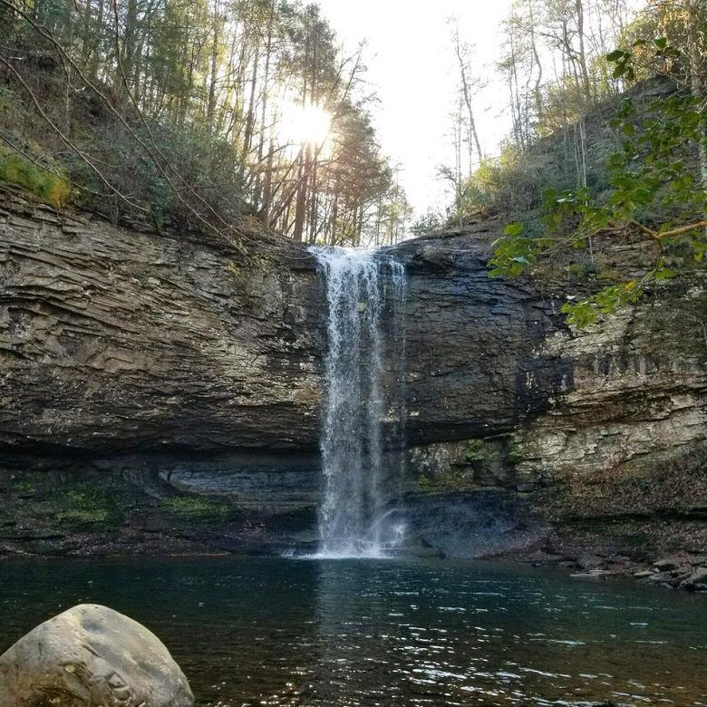
Compared to that, the hike down to Cherokee Falls was a breeze.
Here, you climb between rocks until you’re at the edge of the pool the 60-foot tall waterfall pours into. This waterfall offered a much more picturesque view.
These waterfalls are wonderful winter waterfalls, meaning that their flow is strongest in the winter when water doesn’t evaporate as quickly, but they’re also lovely throughout the year after a heavy rain.
We hiked back up, completing the trail at 2 miles at the Main Trailhead, and we realized that the hike had taken us hardly any time at all. So we decided to branch off at the West Rim Loop Trail and walk for however long we felt.
Bonus Hike: West Rim Loop Trail
The West Rim Loop Trail branches off from the Waterfalls Trail and heads down a flight of metal stairs, but after that, it’s all dirt path.
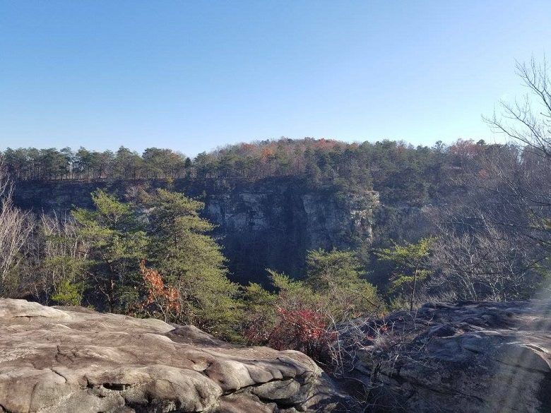
The trail descends into the canyon and crosses a wooden bridge spanning Sitton’s Gulch Creek before climbing back up the west edge of the canyon through a series of switchbacks.
At just over 0.5 miles, the trail passes by a small cave and then the park’s yurts. The trail soon opens up on the right side with rock outcrops and views of the canyon.
The trail heads back into the forest and comes to the loop portion at just over 1 mile. This is where we turned around, as the loop continued for 3 miles and we weren’t up for that kind of hike.
We retraced our steps, completing our hike on the West Rim Loop Trail at about 2.5 miles back at the parking lot. Together with the Waterfalls Trail, it made for a nice 4.5 mile fall hike.
Hiking Essentials
Come prepared for your hike by making sure you pack the essentials. Check out this must-have hiking gear before you set off on the trails:
Cloudland Canyon Waterfalls Trail Info
Hike length: 2 miles
Difficulty: Strenuous
Is it pet-friendly?: Yes, leashed dogs are allowed on this trail. But the metal stairs can be difficult for dogs.
Location: 122 Cloudland Canyon Park Rd, Rising Fawn, GA 30738
Parking: Parking is available at the East Rim Parking Lot (for the West Rim Loop Trail) inside Cloudland Canyon State Park. $10 fee.
Fees: $10 parking fee per vehicle.
Hours: The trail is open from 7 a.m. to dark.
Accessibility: The Waterfalls Trail is a dirt trail with metal steps. It is accessible to hikers. The trail is strenuous and is not suitable for everyone.
Cloudland Canyon State Park
Cloudland Canyon State Park is formed by the flow of Sitton’s Gulch Creek, which drops over 60 feet of rock outcrops to form these waterfalls.
The 3,488 acre state park contains 64 miles of hiking trails, 30 miles of biking trails 16 miles of horseback riding trails.
Where to Stay near Cloudland Canyon State Park
- Top Hotel: Cloudland at McLemore Resort Lookout Mountain, Curio by Hilton
- Great Value: Days Inn by Wyndham Trenton
- Unique Stay: Stone Ledge Refuge with private hot tub
More Georgia State Park Hikes
Check out these other great hikes at these other popular Georgia State Parks.
- Hurricane Falls Trail at Tallulah Gorge State Park
- Amicalola Falls Trail at Amicalola Falls State Park
- Iron Hill Loop Trail at Red Top Mountain State Park
- Stone Wall, Tower, & Overlook Trails at Fort Mountain State Park
- Wild Turkey Trail at Chattahoochee Bend State Park
Ready to visit Cloudland Canyon, Georgia? Plan your trip with these tips.
- Book Your Flight: Find the cheapest flights using Skyscanner, my favorite flight search engine.
- Find Accommodation: You can find top cabins near Cloudland Canyon using VRBO.
- Start Packing: Check out my packing list resources so you’re prepared for your trip.
Cheers!
Paige

Have you hiked the Waterfalls Trail at Cloudland Canyon State Park? Let me know in the comments!